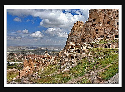
The Vulcan Erciyes and Hasan erupted and formed a soil with very malleable stones yet sturdy in its nature. As a result, intricate carvings of nature and man have been recorded on this seemingly desolate land for centuries. The winding landscape is decorated with a maze of cones, slopes and chimneys at every twist and turn. Before the Persian invasion, Cappadocia extended from the Black Sea in the north, to the Taurus Mountains in the south with the Euphrates and Tatta Rivers bordering it to the east and west. Now, considerably condensed, Cappadocia is enclosed by the Halys River to the north, the Euphrates to the east and the Seyhan and Ceyhan rivers to the south. During the Roman Emperor, Augustus period, territories of Cappadocian Region as a wide region lying till to the Toros Mountains at south, Aksaray at west, Malatya at east and Eastern Black Sea shores at north within the 17 volume book named 'Geographika' of Strabon, one of the Antic Period writers. Today's Cappadocian Region is the area covered by Nevşehir, Aksaray, Niğde, Kayseri, and Kırşehir cities. More limited area, rocky Cappadocian Region is composed of Üçhisar, Göreme, Avanos, Ürgüp, Derinkuyu, Kaymaklı, Ihlara and environment.

 talukder")